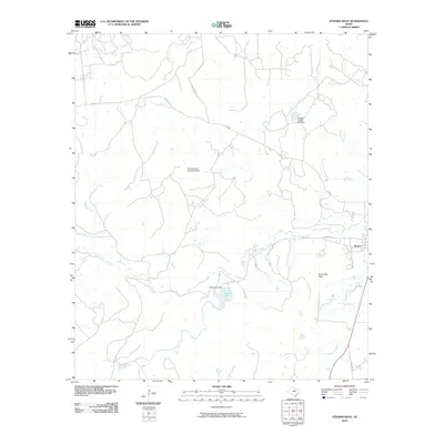
2010 Map of Strawn West
USGS Topo · Published 2010About this map
Strawn anchors the eastern edge of this landscape, where the rolling Texas terrain meets a network of managed water resources and intermittent creek beds. Small-scale ranching and water management define the area, evidenced by infrastructure like Lake Tucker Dam and Double Gates Lake Dam. The topography is marked by notable elevations such as Evensville Peak, overlooking the winding path of Palo Pinto Creek as it moves through the southern reaches of the quadrangle. Several family-named or locality-based roads, including Hohhertz Rd and Morris Ln, connect isolated properties to the primary thoroughfares of FM 207 and S Front St. This 2010 survey provides a look at the modern drainage patterns of Bills Creek and its various tributaries like Cottonwood Creek and Russell Creek, which drain this portion of Palo Pinto County.
Find a feature on this map
22 named features on this map. Tap any name to fly to it.
Don’t see what you’re looking for? This feature index may not catch every label — zoom into the map to look around manually.
Map Details
Editions of this 2010 Strawn West Map
This is the sole edition of this map. No revisions or reprints were ever made.
Other maps of this area

1890 · Stephenville
USGS Topo · 1:125,000

1890 · Breckenridge
USGS Topo · 1:125,000

1891 · Palo Pinto
USGS Topo · 1:125,000

1894 · Eastland
USGS Topo · 1:125,000

1918 · Palo Pinto
USGS Topo · 1:125,000

1920 · Stephenville
USGS Topo · 1:125,000

1954 · Abilene
USGS Topo · 1:250,000

1958 · Abilene
USGS Topo · 1:250,000

1959 · Gordon
USGS Topo · 1:62,500
1965 · Reddy Mountain
USGS Topo · 1:24,000