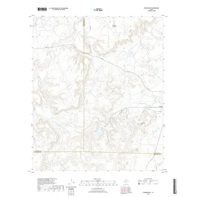
2019 Map of Strawn West
USGS Topo · Published 2019About this map
Strawn occupies the eastern edge of this terrain, situated where the lowlands meet the rising elevations of the Palo Pinto Mountains. The landscape is defined by a dense network of drainage systems, including Bills Cr, S Bills Cr, and Middle Cr, which carve through the high ground. To the south, Evensville Peak stands as a prominent landmark overlooking the waters of Tucker Lake. This 2019 survey documents the junction of Stephens, Eastland, and Palo Pinto counties, illustrating how modern routes like Fm 207 and Fm 2372 navigate the complex topography. Small drainages such as Russell Cr and Gilmore Cr illustrate the intricate watershed that directs flow toward the local basins, providing a clear record of the area's contemporary geography and rural road network.
Find a feature on this map
25 named features on this map. Tap any name to fly to it.
Don’t see what you’re looking for? This feature index may not catch every label — zoom into the map to look around manually.
Map Details
Editions of this 2019 Strawn West Map
This is the sole edition of this map. No revisions or reprints were ever made.
Other maps of this area

1890 · Stephenville
USGS Topo · 1:125,000

1890 · Breckenridge
USGS Topo · 1:125,000

1891 · Palo Pinto
USGS Topo · 1:125,000

1894 · Eastland
USGS Topo · 1:125,000

1918 · Palo Pinto
USGS Topo · 1:125,000

1920 · Stephenville
USGS Topo · 1:125,000

1954 · Abilene
USGS Topo · 1:250,000

1958 · Abilene
USGS Topo · 1:250,000

1959 · Gordon
USGS Topo · 1:62,500
1965 · Reddy Mountain
USGS Topo · 1:24,000