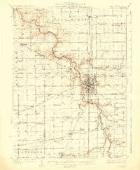
1927 Map of Streator
USGS Topo · Published 1927About this map
The Vermilion River carves a deep valley through this north-central Illinois landscape, serving as the industrial and geographical anchor for Streator. In the mid-1920s, this area was a dense network of steam-era transportation, where the Chicago Burlington and Quincy and New York Central railroads intersect at the coal-mining hub of Streator. The map reveals a countryside still defined by small-scale civic life, with dozens of family-named schools like Patterson School and Mc Combs School spaced for a walking rural population. Local religious history is well-represented by diverse landmarks, including St Marys Church, the German Methodist Church, and the Holiness Tabernacle. Beyond the urban core, small settlements like Kangley and Leonore stand alongside significant recreational spaces such as Marilla Park, illustrating the balance between industry and community at the edge of the La Salle and Livingston County line.
Find a feature on this map
97 named features on this map. Tap any name to fly to it.
Don’t see what you’re looking for? This feature index may not catch every label — zoom into the map to look around manually.
Map Details
Editions of this 1927 Streator Map
2 editions found
Other maps of this area

1892 · Marseilles
USGS Topo · 1:62,500

1892 · Ottawa
USGS Topo · 1:62,500

1893 · Lasalle
USGS Topo · 1:62,500

1911 · La Salle
USGS Topo · 1:62,500

1913 · La Salle
USGS Topo · 1:62,500

1915 · Ottawa
USGS Topo · 1:62,500

1916 · Marseilles
USGS Topo · 1:62,500

1925 · Streator
USGS Topo · 1:62,500

1927 · Streator
USGS Topo · 1:62,500

1934 · Wenona
USGS Topo · 1:48,000