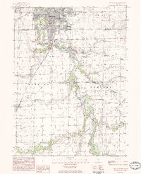
1983 Map of Streator South
USGS Topo · Published 1984About this map
The industrial and agricultural landscape south of Streator is defined by the winding course of the Vermilion River and the legacy of its extraction industries. This 1979 field-checked survey reveals the city’s southward expansion, marked by institutional landmarks like St Marys Hosp and numerous parochial centers including St Marys Cath Ch and St Stephen Cath Ch. Evidence of the region’s economic foundations appears in the form of a Clay Pit and multiple Mine Dump sites, indicating the coal and clay mining that once drove the local economy.
Find a feature on this map
61 named features on this map. Tap any name to fly to it.
Don’t see what you’re looking for? This feature index may not catch every label — zoom into the map to look around manually.
Map Details
Editions of this 1983 Streator South Map
This is the sole edition of this map. No revisions or reprints were ever made.
Other maps of this area

1925 · Streator
USGS Topo · 1:62,500

1927 · Streator
USGS Topo · 1:62,500

1935 · Pontiac
USGS Topo · 1:62,500

1939 · Pontiac
USGS Topo · 1:62,500

1958 · Flanagan
USGS Topo · 1:62,500

1958 · Odell
USGS Topo · 1:62,500

1958 · Aurora
USGS Topo · 1:250,000

1958 · Peoria
USGS Topo · 1:250,000

1961 · Aurora
USGS Topo · 1:250,000

1961 · Peoria
USGS Topo · 1:250,000