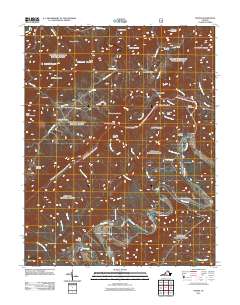
2011 Map of Strom
USGS Topo · Published 2011About this map
Craig Creek defines the lower half of this landscape, its winding course tracing a path between Deisher Mountain and the southern slopes of the Rich Patch Mountains. This corner of Botetourt County is marked by a deep-rooted industrial and agricultural history, visible in the cluster of small settlements like Rich Patch, Parr, and Surber. The presence of Grace Furnace and specialized sites like the Ritchpatch Mine and Peanut Mine point to the area’s iron and mining heritage. Genealogists will find a high density of family-named burial grounds, including Rose Hill Cemetery, Simmons Cemetery, and the King Memorial Cemetery. The terrain is characterized by prominent peaks such as Howard Knob and Bald Knob, while the river network remains the primary corridor for movement, featuring crossing points like Hollow Ford and the historic Hooks Mill.
Find a feature on this map
61 named features on this map. Tap any name to fly to it.
Don’t see what you’re looking for? This feature index may not catch every label — zoom into the map to look around manually.
Map Details
Editions of this 2011 Strom Map
This is the sole edition of this map. No revisions or reprints were ever made.
Other maps of this area

1887 · Lewisburg
USGS Topo · 1:125,000

1891 · Lewisburg
USGS Topo · 1:125,000

1894 · Natural Bridge
USGS Topo · 1:125,000

1913 · Eagle Rock
USGS Topo · 1:48,000

1915 · Eagle Rock
USGS Topo · 1:62,500

1921 · Callaghan
USGS Topo · 1:48,000

1923 · Callaghan
USGS Topo · 1:62,500

1945 · Clifton Forge
USGS Topo · 1:62,500
1945 · New Castle
USGS Topo · 1:62,500
1946 · Callaghan
USGS Topo · 1:62,500