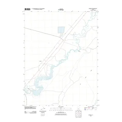
2010 Map of Strong
USGS Topo · Published 2010About this map
The Sevier River winds through this arid Millard County landscape, heavily managed by a network of irrigation and water storage infrastructure. The D M A D Reservoir dominates the western half of the map, contained by the D M A D Dam and a secondary Diversion Dam. These structures facilitate the distribution of water into a series of conduits, including Canal A and the Central Utah Canal, supporting agriculture in this desert region. The settlement of Strong sits at a crossroads where the river system meets rural routes like W 800 S. To the east, the terrain transitions into the Oak Creek Sinks, where ephemeral drainage features like Big Gully reveal the natural hydrology of the Great Basin floor before it was altered by early 21st-century water management.
Find a feature on this map
11 named features on this map. Tap any name to fly to it.
Don’t see what you’re looking for? This feature index may not catch every label — zoom into the map to look around manually.
Map Details
Editions of this 2010 Strong Map
This is the sole edition of this map. No revisions or reprints were ever made.
Other maps of this area

1885 · Sevier Desert
USGS Topo · 1:250,000

1951 · Oak City
USGS Topo · 1:62,500

1953 · Delta
USGS Topo · 1:250,000

1958 · Delta
USGS Topo · 1:250,000

1962 · Delta
USGS Topo · 1:250,000

1962 · Lynndyl
USGS Topo · 1:62,500

1962 · Delta
USGS Topo · 1:62,500

1971 · Rain Lake
USGS Topo · 1:24,000

1979 · Lynndyl
USGS Topo · 1:100,000
1985 · Harding
USGS Topo · 1:24,000