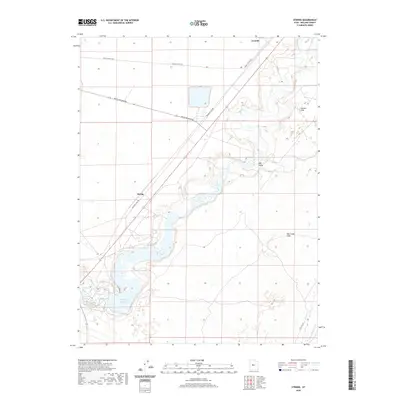
2020 Map of Strong
USGS Topo · Published 2020About this map
The Sevier River dominates this portion of Millard County, winding through a desert landscape defined by hydraulic engineering and historical transit corridors. At the heart of the region lies the DMAD Reservoir, a vital water management feature fed by the river and supported by a network of man-made waterways including Canal A and the Central Utah Canal. The settlement of Lynndyl and the point of Strong mark the human presence in this arid environment, connected by a grid of specialized routes such as Brush Wellman Rd and Railroad View Rd. Distinctive natural landmarks like the Oak Creek Sinks, Big Gully, and Taylors Flat illustrate the complex drainage patterns and terrain of the Sevier Desert. This modern survey provides a clear view of how water diversion remains the central organizing principle for life and industry in the area around Delta.
Find a feature on this map
13 named features on this map. Tap any name to fly to it.
Don’t see what you’re looking for? This feature index may not catch every label — zoom into the map to look around manually.
Map Details
Editions of this 2020 Strong Map
This is the sole edition of this map. No revisions or reprints were ever made.
Other maps of this area

1885 · Sevier Desert
USGS Topo · 1:250,000

1951 · Oak City
USGS Topo · 1:62,500

1953 · Delta
USGS Topo · 1:250,000

1958 · Delta
USGS Topo · 1:250,000

1962 · Delta
USGS Topo · 1:250,000

1962 · Lynndyl
USGS Topo · 1:62,500

1962 · Delta
USGS Topo · 1:62,500

1971 · Rain Lake
USGS Topo · 1:24,000

1979 · Lynndyl
USGS Topo · 1:100,000
1985 · Harding
USGS Topo · 1:24,000