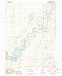
1985 Map of Strong
USGS Topo · Published 1985About this map
The Sevier River winds through this arid landscape of Millard County, defining the local geography as it feeds into the DMAD Reservoir. This mid-1980s provisional survey illustrates the complex water management system of the region, featuring the Central Utah Canal, a Spillway, and an Abandoned Canal that speaks to shifting irrigation patterns. Near the settlement of Strong, the terrain transitions from the distinct Sand Dunes in the northwest to the low-lying Oak Creek Sinks in the southeast. Evidence of local utility and infrastructure is visible through the presence of a Gaging Station, several Tanks, and a Gravel Pit. The map also delineates an Airport boundary and the expansive Taylors Flat, providing a detailed view of how this desert environment was utilized for both resource management and transportation during this era.
Find a feature on this map
15 named features on this map. Tap any name to fly to it.
Don’t see what you’re looking for? This feature index may not catch every label — zoom into the map to look around manually.
Map Details
Editions of this 1985 Strong Map
This is the sole edition of this map. No revisions or reprints were ever made.
Other maps of this area

1885 · Sevier Desert
USGS Topo · 1:250,000

1951 · Oak City
USGS Topo · 1:62,500

1953 · Delta
USGS Topo · 1:250,000

1958 · Delta
USGS Topo · 1:250,000

1962 · Delta
USGS Topo · 1:250,000

1962 · Lynndyl
USGS Topo · 1:62,500

1962 · Delta
USGS Topo · 1:62,500

1971 · Rain Lake
USGS Topo · 1:24,000

1979 · Lynndyl
USGS Topo · 1:100,000
1985 · Harding
USGS Topo · 1:24,000