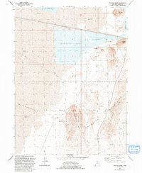
1991 Map of Strongs Knob
USGS Topo · Published 1991About this map
The Lucin Cutoff traverses a landscape dominated by the salt-heavy environment of the Great Salt Lake's western reaches. This 1991 revision illustrates a highly specialized industrial and military geography, where the Evaporator Pond and numerous Prospects indicate active mineral extraction near Lakeside Butte. To the north, Strongs Knob rises above the transition between Clyman Bay and Gunnison Bay, surrounded by expansive areas of Mud that characterize the shifting shoreline. The southern portion of the sheet is largely occupied by the Utah Test and Training Range North, a restricted military zone that encompasses rugged landmarks like Homestead Knoll and The Horseshoe. Between the Lakeside Mountains and the salt flats, narrow corridors like Death Valley and Sedal Valley connect through Sedal Pass, reflecting the stark, remote terrain of the eastern Basin and Range province.
Find a feature on this map
30 named features on this map. Tap any name to fly to it.
Don’t see what you’re looking for? This feature index may not catch every label — zoom into the map to look around manually.
Map Details
Editions of this 1991 Strongs Knob Map
This is the sole edition of this map. No revisions or reprints were ever made.
Other maps of this area

1954 · Brigham City
USGS Topo · 1:250,000

1958 · Brigham City
USGS Topo · 1:250,000

1962 · Brigham City
USGS Topo · 1:250,000

1968 · Deardens Knoll
USGS Topo · 1:24,000

1969 · Gunnison Island SW
USGS Topo · 1:24,000

1969 · Hogup Ridge South
USGS Topo · 1:24,000

1969 · Strongs Knob
USGS Topo · 1:24,000

1969 · Gunnison Island
USGS Topo · 1:24,000
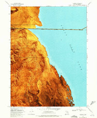
1969 · Lakeside
USGS Topo · 1:24,000

1969 · Hogup Ridge North
USGS Topo · 1:24,000