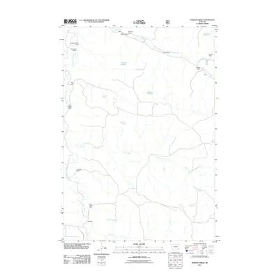
2011 Map of Stroud Creek
USGS Topo · Published 2011About this map
OW Ranch anchors the southern portion of this cattle country landscape in Rosebud County, where the high plains are carved by a complex network of ephemeral drainages. The topography is defined by the systems of Lee Creek, Stroud Creek, and Hanging Woman Creek, which are fed by numerous named draws and gulches including Gloomy Glenn Draw and Mare Pasture Gulch. This 2011 survey reveals how water management shapes the area, with several livestock reservoirs such as Haywood Reservoir and Snyder Reservoir distributed across the range. Strategic water sources like Dutchman Spring and Rim Rock Spring provide critical points of interest for land use in this open country. The transportation network is minimal, consisting primarily of Otter Decker Rd and Hanging Woman Rd, which follow the natural contours of the creek valleys to connect these remote ranching outposts.
Find a feature on this map
30 named features on this map. Tap any name to fly to it.
Don’t see what you’re looking for? This feature index may not catch every label — zoom into the map to look around manually.
Map Details
Editions of this 2011 Stroud Creek Map
This is the sole edition of this map. No revisions or reprints were ever made.
Other maps of this area

1954 · Hardin
USGS Topo · 1:250,000

1957 · Hardin
USGS Topo · 1:250,000

1958 · Hardin
USGS Topo · 1:250,000

1966 · Browns Mountain
USGS Topo · 1:24,000

1966 · Poker Jim Butte
USGS Topo · 1:24,000

1967 · Birney
USGS Topo · 1:24,000

1967 · Lacey Gulch
USGS Topo · 1:24,000
1967 · Pine Butte School
USGS Topo · 1:24,000
1972 · Stroud Creek
USGS Topo · 1:24,000
1972 · Forks Ranch
USGS Topo · 1:24,000