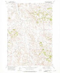
1972 Map of Forks Ranch
USGS Topo · Published 1975About this map
Hanging Woman Creek defines the drainage pattern of this high plains ranching landscape in southeastern Montana. Surveyed in the early 1970s, the map centers on the Forks Ranch and reveals a remote environment where water management and cattle operations are paramount. Prominent landforms such as Hellers Peak, Hampton Butte, and Old Flat Top provided essential orientation for early settlers and ranchers in an area otherwise dominated by a complex network of ephemeral watercourses including Negro Draw and First Deadman Draw. The mapping of several Drill Holes and Wells points to the systematic exploration of subterranean resources and the necessity of water access for livestock. Navigating this terrain required an intricate system of Trails and Jeep Trails, showing how the local economy adapted to the broken topography of the Big Horn region.
Find a feature on this map
25 named features on this map. Tap any name to fly to it.
Don’t see what you’re looking for? This feature index may not catch every label — zoom into the map to look around manually.
Map Details
Editions of this 1972 Forks Ranch Map
This is the sole edition of this map. No revisions or reprints were ever made.
Other maps of this area

1909 · Sheridan
USGS Topo · 1:125,000

1911 · Sheridan
USGS Topo · 1:125,000

1954 · Hardin
USGS Topo · 1:250,000

1955 · Sheridan
USGS Topo · 1:250,000

1957 · Hardin
USGS Topo · 1:250,000

1958 · Hardin
USGS Topo · 1:250,000

1958 · Sheridan
USGS Topo · 1:250,000

1962 · Sheridan
USGS Topo · 1:250,000

1967 · Lacey Gulch
USGS Topo · 1:24,000
1967 · Pine Butte School
USGS Topo · 1:24,000