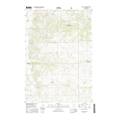
2017 Map of Stroud Creek
USGS Topo · Published 2017About this map
Custer National Forest lands dominate the high ground in this 2017 survey of the border between Rosebud and Big Horn counties. The drainage patterns of the northern Tongue River basin are clearly defined by a series of named draws and gulches, including the evocative Gloomy Glenn Draw and Mare Pasture Gulch. Ranching and water management are the primary human imprints on this arid landscape, evidenced by several isolated reservoirs and springs. Vital water sources like Woodard Reservoir, Snyder Reservoir, and Dutchman Spring are essential for supporting livestock in the vicinity of Hanging Woman Cr. The topography is navigated by a sparse network of secondary roads, notably Otter Rd and Decker Rd, which follow the natural contours of the drainages like Stroud Cr and Horse Cr.
Find a feature on this map
31 named features on this map. Tap any name to fly to it.
Don’t see what you’re looking for? This feature index may not catch every label — zoom into the map to look around manually.
Map Details
Editions of this 2017 Stroud Creek Map
This is the sole edition of this map. No revisions or reprints were ever made.
Other maps of this area

1954 · Hardin
USGS Topo · 1:250,000

1957 · Hardin
USGS Topo · 1:250,000

1958 · Hardin
USGS Topo · 1:250,000

1966 · Browns Mountain
USGS Topo · 1:24,000

1966 · Poker Jim Butte
USGS Topo · 1:24,000

1967 · Birney
USGS Topo · 1:24,000

1967 · Lacey Gulch
USGS Topo · 1:24,000
1967 · Pine Butte School
USGS Topo · 1:24,000
1972 · Stroud Creek
USGS Topo · 1:24,000
1972 · Forks Ranch
USGS Topo · 1:24,000