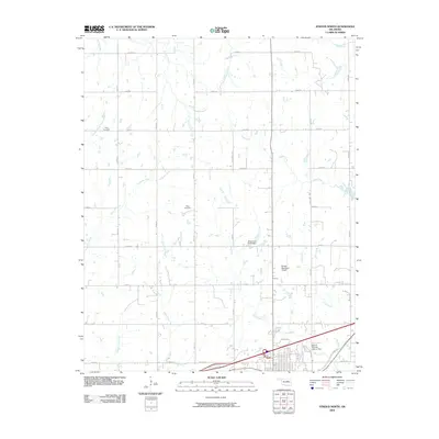
2009 Map of Stroud North
USGS Topo · Published 2009About this map
Henry Cemetery and Black Cemetery anchor the rural landscape of Lincoln County in this early 21st-century survey, reflecting the generational roots of the area north of Stroud. The terrain is defined by a dense network of watercourses, including the westward-flowing Salt Creek, Euchee Creek, and the curiously named Possum Trot Creek. While much of the land remains divided by a traditional section-line road grid—marked by routes like n3520 RD and e0800 RD—the southern edge of the map shows the modernization of Oklahoma's infrastructure. This includes the development of the Stroud Municipal Airport and the complex Stroud Interchange, which connects local travel to the regional corridor. Traces of the past remain visible along the alignment of Old US Hwy 66, which skirts the southeastern corner of the quadrangle, serving as a reminder of the era before the interstate bypass.
Find a feature on this map
38 named features on this map. Tap any name to fly to it.
Don’t see what you’re looking for? This feature index may not catch every label — zoom into the map to look around manually.
Map Details
Editions of this 2009 Stroud North Map
This is the sole edition of this map. No revisions or reprints were ever made.
Other maps of this area

1905 · Chandler
USGS Topo · 1:62,500

1907 · Chandler
USGS Topo · 1:62,500

1908 · Agra
USGS Topo · 1:62,500

1929 · Stroud
USGS Topo · 1:62,500

1931 · Drumright
USGS Topo · 1:62,500

1932 · Stroud
USGS Topo · 1:62,500

1954 · Oklahoma City
USGS Topo · 1:250,000

1957 · Oklahoma City
USGS Topo · 1:250,000

1963 · Oklahoma City
USGS Topo · 1:250,000
1974 · Davenport
USGS Topo · 1:24,000