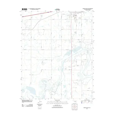
2012 Map of Stroud South
USGS Topo · Published 2012About this map
Stroud anchors the northern edge of this landscape, where the local street grid including W Central St and W Joe St transitions into the section-line roads of Lincoln County. The area is defined by the winding course of the Deep Fork river and its many tributaries, such as Wild Horse Cr and Gray Horse Cr, which feed into several local bodies of water like Todd Lake and Browns Lake. This hydrography suggests a terrain shaped by the alluvial plains of the Deep Fork. For those tracing local heritage, the map identifies several geographically distinct burial sites, including the Stroud Cem near the town center and more remote locations such as Victor Cem and Rock Island Cem to the south. The small settlement of Smith and numerous rural junctions provide additional points of reference for the region's twentieth-century development.
Find a feature on this map
54 named features on this map. Tap any name to fly to it.
Don’t see what you’re looking for? This feature index may not catch every label — zoom into the map to look around manually.
Map Details
Editions of this 2012 Stroud South Map
This is the sole edition of this map. No revisions or reprints were ever made.
Other maps of this area

1905 · Chandler
USGS Topo · 1:62,500

1907 · Chandler
USGS Topo · 1:62,500

1908 · Agra
USGS Topo · 1:62,500

1929 · Stroud
USGS Topo · 1:62,500

1931 · Drumright
USGS Topo · 1:62,500

1932 · Stroud
USGS Topo · 1:62,500

1954 · Oklahoma City
USGS Topo · 1:250,000

1957 · Oklahoma City
USGS Topo · 1:250,000

1963 · Oklahoma City
USGS Topo · 1:250,000
1974 · Arlington
USGS Topo · 1:24,000