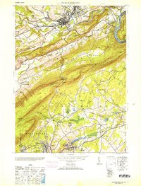
1953 Map of Stroudsburg
USGS Topo · Published 1953About this map
The boroughs of Stroudsburg and East Stroudsburg serve as the hub of this early 1950s survey, illustrating the dense social and industrial landscape of Monroe County. Education and manufacturing are central to the local economy, marked by the presence of State Teachers College and specialized industrial sites like the Hosiery Mills and Silk Mills. The geography is dominated by the dramatic southwest-to-northeast ridges of Godfrey Ridge and the Kittatinny Mountains, which guide the path of Cherry Creek and the Delaware Lackawanna and Western railroad toward the iconic Delaware Water Gap.
Find a feature on this map
80 named features on this map. Tap any name to fly to it.
Don’t see what you’re looking for? This feature index may not catch every label — zoom into the map to look around manually.
Map Details
Editions of this 1953 Stroudsburg Map
2 editions found
Other maps of this area

1891 · Delaware Water Gap
USGS Topo · 1:62,500

1893 · Delaware Water Gap
USGS Topo · 1:62,500

1914 · Wind Gap
USGS Topo · 1:62,500

1916 · Wind Gap
USGS Topo · 1:62,500

1919 · Pocono
USGS Topo · 1:62,500

1921 · Pocono
USGS Topo · 1:62,500

1923 · Pocono
USGS Topo · 1:62,500

1924 · Bushkill
USGS Topo · 1:48,000

1936 · Delaware Water Gap
USGS Topo · 1:48,000

1941 · Delaware Water Gap
USGS Topo · 1:62,500