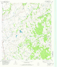
1982 Map of Structure
USGS Topo · Published 1982About this map
The community of Structure serves as a central landmark for this rural landscape where the boundaries of Williamson, Bastrop, Travis, and Lee counties converge. In the early 1980s, the region was defined by its intricate drainage systems, including Brushy Creek and Middle Yegua Creek, which carved through the terrain alongside the rail line of the Missouri Kansas Texas railroad. Family and community heritage is deeply rooted here, visible through several rural burial sites such as Mager Cem, Type Cem, and Pleasant Grove Cem. Local landmarks like the Lakeview Ch and the settlement of Siloam indicate established social hubs. The map also documents the transition to modern infrastructure with a prominent Pipeline and multiple substations, while maintaining its agricultural character near Lawhon Springs.
Find a feature on this map
31 named features on this map. Tap any name to fly to it.
Don’t see what you’re looking for? This feature index may not catch every label — zoom into the map to look around manually.
Map Details
Editions of this 1982 Structure Map
This is the sole edition of this map. No revisions or reprints were ever made.
Other maps of this area

1885 · Taylor
USGS Topo · 1:125,000

1885 · Bastrop
USGS Topo · 1:125,000

1887 · Taylor
USGS Topo · 1:125,000

1893 · Bastrop
USGS Topo · 1:125,000

1894 · Taylor
USGS Topo · 1:125,000

1904 · Bastrop
USGS Topo · 1:125,000

1948 · Elgin
USGS Topo · 1:62,500

1948 · Lexington
USGS Topo · 1:62,500

1950 · Lexington
USGS Topo · 1:62,500

1950 · Elgin
USGS Topo · 1:62,500