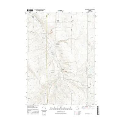
2016 Map of Strykersville
USGS Topo · Published 2016About this map
Buffalo Creek and its many tributaries, including Sheldon Creek and Beaver Meadow Creek, define the rolling landscape across the border of Erie and Wyoming Counties. This area is characterized by small, dispersed hamlets such as Strykersville, Java Village, and Wales Hollow, connected by a network of rural roads like Holland RD and Wales Creek RD. The map is particularly rich for genealogical research, documenting numerous parish and community burial sites such as Saint Marys Cem, Saint Patrick's Cem, and the historic Strykersville Pioneer Cem. Higher elevations like Crow Hill and Vermont Hill overlook the narrow valleys where agriculture and small-town life persist. The inclusion of the Bloecher Farm Airport near the northern boundary highlights the specialized land use found in this part of Western New York.
Find a feature on this map
64 named features on this map. Tap any name to fly to it.
Don’t see what you’re looking for? This feature index may not catch every label — zoom into the map to look around manually.
Map Details
Editions of this 2016 Strykersville Map
This is the sole edition of this map. No revisions or reprints were ever made.
Other maps of this area

1905 · Attica
USGS Topo · 1:62,500

1905 · Depew
USGS Topo · 1:62,500

1923 · Arcade
USGS Topo · 1:62,500

1925 · Springville
USGS Topo · 1:62,500

1925 · Arcade
USGS Topo · 1:62,500

1948 · Depew
USGS Topo · 1:62,500

1949 · Attica
USGS Topo · 1:62,500

1949 · Cowlesville
USGS Topo · 1:24,000
1949 · Attica
USGS Topo · 1:24,000
1950 · East Aurora
USGS Topo · 1:24,000