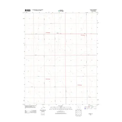
2013 Map of Stuart
USGS Topo · Published 2013About this map
Stuart sits as the central point of reference in this Kiowa County landscape, where the high plains are defined by a rigid section-line grid. This modern survey illustrates the enduring Public Land Survey System structure, with the township lines of t018s r043w and t018s r042w meeting along north-south corridors like Co Road 71. The settlement is positioned along Main St, which serves as a primary east-west axis alongside Co Highway N. The terrain is characterized by subtle elevation changes and drainage patterns that break the geometric precision of the road network, which includes routes such as Co Road 72 and Co Road S. This map provides a clear record of the rural infrastructure and land divisions that continue to shape eastern Colorado's agricultural character.
Find a feature on this map
17 named features on this map. Tap any name to fly to it.
Don’t see what you’re looking for? This feature index may not catch every label — zoom into the map to look around manually.
Map Details
Editions of this 2013 Stuart Map
This is the sole edition of this map. No revisions or reprints were ever made.
Other maps of this area

1890 · Granada
USGS Topo · 1:125,000

1892 · Cheyenne Wells
USGS Topo · 1:125,000

1892 · Granada
USGS Topo · 1:125,000

1894 · Cheyenne Wells
USGS Topo · 1:125,000

1894 · Granada
USGS Topo · 1:125,000

1954 · Lamar
USGS Topo · 1:250,000

1958 · Lamar
USGS Topo · 1:250,000

1968 · Stuart
USGS Topo · 1:24,000

1968 · Sheridan Lake
USGS Topo · 1:24,000
1968 · Sheridan Lake SE
USGS Topo · 1:24,000