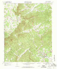
1967 Map of Stuart
USGS Topo · Published 1971About this map
The town of Stuart serves as the focal point of this Patrick County survey, where the South Fork Mayo River and North Fork Mayo River converge. This 1967 mapping captures the settlement pattern of the Blue Ridge foothills, showing the Blue Ridge Parkway winding along the western edge near Vesta. The terrain is defined by prominent peaks like Bull Mountain, Spoon Mtn, and Tobacco Knob, creating a landscape where roads and small communities are dictated by the underlying topography. Local social centers are clearly marked, from the Stuart High Sch to numerous rural congregations including Bouldin Memorial Ch and Dan River Ch. This document offers a clear look at the region's hydrography, featuring the Smith River Falls and the winding course of Buffalo Creek, illustrating the early connectivity between high-altitude ridges and the lower river valleys.
Find a feature on this map
46 named features on this map. Tap any name to fly to it.
Don’t see what you’re looking for? This feature index may not catch every label — zoom into the map to look around manually.
Map Details
Editions of this 1967 Stuart Map
2 editions found
Other maps of this area

1926 · Critz
USGS Topo · 1:48,000

1928 · Stuart
USGS Topo · 1:48,000

1928 · Critz
USGS Topo · 1:62,500

1931 · Stuart
USGS Topo · 1:62,500

1953 · Winston-Salem
USGS Topo · 1:250,000

1955 · Winston-Salem
USGS Topo · 1:250,000

1957 · Endicott
USGS Topo · 1:62,500

1957 · Floyd
USGS Topo · 1:62,500

1962 · Winston-Salem
USGS Topo · 1:250,000

1967 · Patrick Springs
USGS Topo · 1:24,000