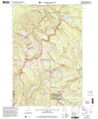
1999 Map of Stuart Peak
USGS Topo · Published 2003About this map
McLeod Peak and Stuart Peak anchor a high-altitude landscape defined by overlapping jurisdictional boundaries in the northern reaches of Missoula County. This late-twentieth-century revision illustrates the intersection of the Flathead Indian Reservation, which occupies the northwest quadrant, and the Rattlesnake Wilderness to the southeast. The South Fork Jocko Tribal Primitive Area dominates the northern terrain, where Lake Sa-ol-Sooth and Crazy Fish Lake feed into the complex drainage system of the South Fork Jocko. To the southwest, the development of recreational infrastructure is evident at the Montana Snowbowl ski area, featuring a Ski Tow and the Point Six Communication Site. Between these peaks, a dense network of alpine lakes—including Big Lake, Glacier Lake, and Sanders Lake—marks the transition between managed forest and protected wilderness.
Find a feature on this map
43 named features on this map. Tap any name to fly to it.
Don’t see what you’re looking for? This feature index may not catch every label — zoom into the map to look around manually.
Map Details
Editions of this 1999 Stuart Peak Map
This is the sole edition of this map. No revisions or reprints were ever made.
Other maps of this area

1903 · Bonner
USGS Topo · 1:125,000

1912 · Missoula
USGS Topo · 1:125,000

1921 · Elbow Lake
USGS Topo · 1:125,000

1947 · Butte
USGS Topo · 1:250,000

1955 · Choteau
USGS Topo · 1:250,000

1956 · Wallace
USGS Topo · 1:250,000

1956 · Hamilton
USGS Topo · 1:250,000

1957 · Choteau
USGS Topo · 1:250,000

1958 · Butte
USGS Topo · 1:250,000

1958 · Choteau
USGS Topo · 1:250,000