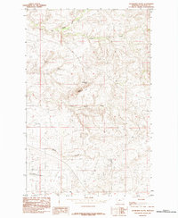
1984 Map of Studhorse Butte
USGS Topo · Published 1984About this map
Studhorse Butte and the surrounding high plains of Chouteau County are defined by a complex drainage system that carves through the Montana landscape. This 1984 provisional survey illustrates the confluence of several significant seasonal and perennial watercourses, most notably Big Sandy Creek and Little Sandy Creek, which navigate the township lines in the central portion of the sheet. The terrain is further shaped by Godfrey Creek to the north and deep cuts like Alkali Coulee and Lonetree Coulee in the south.
Find a feature on this map
7 named features on this map. Tap any name to fly to it.
Don’t see what you’re looking for? This feature index may not catch every label — zoom into the map to look around manually.
Map Details
Editions of this 1984 Studhorse Butte Map
This is the sole edition of this map. No revisions or reprints were ever made.
Other maps of this area

1890 · Fort Benton
USGS Topo · 1:250,000

1892 · Fort Benton
USGS Topo · 1:250,000

1897 · Fort Benton
USGS Topo · 1:250,000

1919 · Big Sandy
USGS Topo · 1:125,000

1953 · Lonetree Coulee
USGS Topo · 1:24,000

1953 · Pilot Rock
USGS Topo · 1:24,000

1953 · Havre
USGS Topo · 1:250,000

1954 · Great Falls
USGS Topo · 1:250,000

1954 · Shelby
USGS Topo · 1:250,000

1954 · Lewistown
USGS Topo · 1:250,000