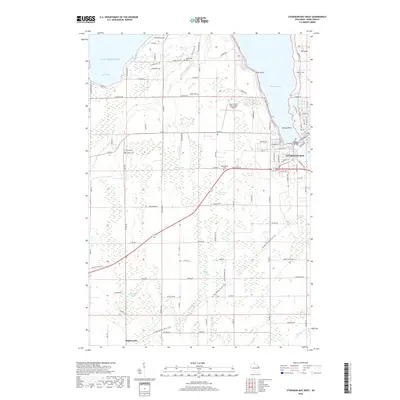
2018 Map of Sturgeon Bay West
USGS Topo · Published 2018About this map
The western waterfront of Sturgeon Bay serves as a focal point for this 2018 survey, where the Sturgeon Bay Bridge connects the city's street grid across the narrow waterway. This coastal Wisconsin landscape transitions from the urban density near Dunlap Reef to a series of wetlands and agricultural lands to the southwest. The geography is defined by significant swamp systems, including Greenwood Swamp, Larson Swamp, and Cunningham Swamp, which highlight the low-lying nature of the Door Peninsula interior. Near the southern edge of the sheet, the settlement of Maplewood sits near the headwaters of Stony Creek. Genealogists will find several burial grounds documented across the rural landscape, from Bayside Cemetery on the northern coast to Schulties Cemetery and Salem Cemetery further inland. The presence of the Door County Cherryland Airport and the Ice Age National Scenic Trail indicate the area's modern role as a regional transportation and recreation hub.
Find a feature on this map
109 named features on this map. Tap any name to fly to it.
Don’t see what you’re looking for? This feature index may not catch every label — zoom into the map to look around manually.
Map Details
Editions of this 2018 Sturgeon Bay West Map
This is the sole edition of this map. No revisions or reprints were ever made.
Other maps of this area

1952 · Casco
USGS Topo · 1:62,500

1954 · Manitowoc
USGS Topo · 1:250,000

1958 · Manitowoc
USGS Topo · 1:250,000

1960 · Sturgeon Bay
USGS Topo · 1:62,500

1960 · Algoma
USGS Topo · 1:62,500

1961 · Little Sturgeon
USGS Topo · 1:62,500

1978 · Brussels
USGS Topo · 1:24,000

1981 · Sturgeon Bay West
USGS Topo · 1:24,000

1981 · Institute
USGS Topo · 1:24,000
1981 · Idlewild
USGS Topo · 1:24,000