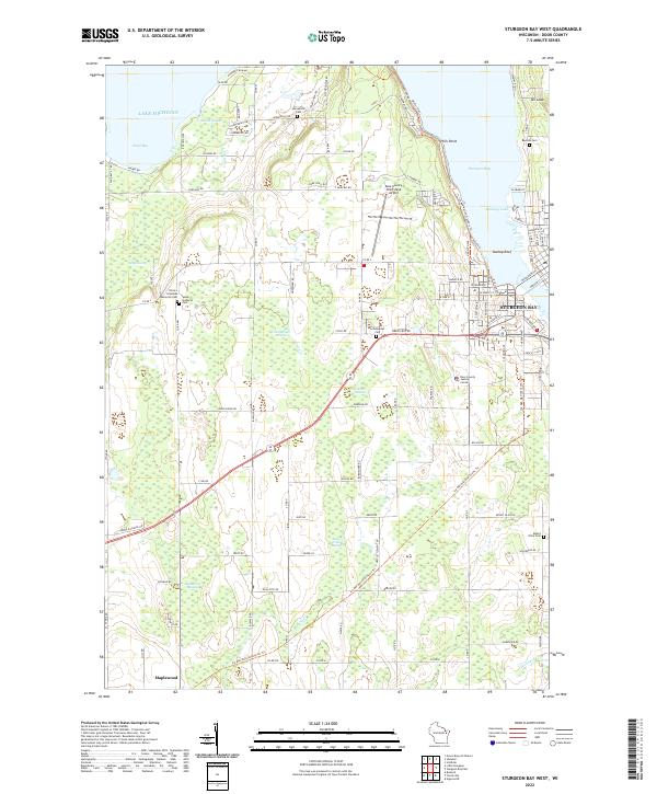
2022 Map of Sturgeon Bay West
USGS Topo · Published 2022About this map
Lake Michigan dominates the northwestern reaches of this Door County coastline, where Sand Bay meets a landscape defined by extensive wetland networks. Further inland, the terrain is characterized by numerous named swamps, including Larson Swamp, May Swamp, and Greenwood Swamp, which suggest a historically difficult area for large-scale development outside of the primary corridors. The city of Sturgeon Bay serves as the focal point in the northeast, overlooking Dunlap Reef and Bradley Lake.
Find a feature on this map
98 named features on this map. Tap any name to fly to it.
Don’t see what you’re looking for? This feature index may not catch every label — zoom into the map to look around manually.
Map Details
Editions of this 2022 Sturgeon Bay West Map
This is the sole edition of this map. No revisions or reprints were ever made.
Other maps of this area

1952 · Casco
USGS Topo · 1:62,500

1954 · Manitowoc
USGS Topo · 1:250,000

1958 · Manitowoc
USGS Topo · 1:250,000

1960 · Sturgeon Bay
USGS Topo · 1:62,500

1960 · Algoma
USGS Topo · 1:62,500

1961 · Little Sturgeon
USGS Topo · 1:62,500

1978 · Brussels
USGS Topo · 1:24,000

1981 · Sturgeon Bay West
USGS Topo · 1:24,000

1981 · Institute
USGS Topo · 1:24,000
1981 · Idlewild
USGS Topo · 1:24,000