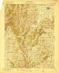
1917 Map of Sturgeon
USGS Topo · Published 1917About this map
The Wabash railroad corridor serves as the primary artery for northern Boone County, anchored by the rail hub of Sturgeon. This landscape, surveyed shortly before the First World War, is defined by a dense network of country schools that once anchored local rural life. Features like Indian Mound School, Red Rock School, and Bethlehem School are spaced across a terrain carved by the complex drainages of Perche Creek and Silver Fork.
Find a feature on this map
59 named features on this map. Tap any name to fly to it.
Don’t see what you’re looking for? This feature index may not catch every label — zoom into the map to look around manually.
Map Details
Editions of this 1917 Sturgeon Map
3 editions found
Other maps of this area

1886 · Jefferson City
USGS Topo · 1:125,000

1888 · Boonville
USGS Topo · 1:125,000

1890 · Moberly
USGS Topo · 1:125,000

1890 · Glasgow
USGS Topo · 1:125,000

1894 · Jefferson City
USGS Topo · 1:125,000

1917 · Sturgeon
USGS Topo · 1:62,500

1935 · Columbia
USGS Topo · 1:24,000

1940 · Columbia
USGS Topo · 1:24,000

1944 · Millersburg
USGS Topo · 1:62,500

1945 · Centralia
USGS Topo · 1:62,500