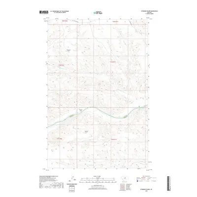
2020 Map of Sturgeon Island
USGS Topo · Published 2020About this map
The Missouri River carves through this remote stretch of Central Montana, serving as the natural boundary between Blaine County and Fergus County. Centrally located within the river's winding path is Sturgeon Island, a prominent landform surrounded by a complex network of seasonal drainages. The landscape is defined by the deep incisions of Bullwhacker Coulee and Little Bullwhacker Cr to the north, while Woodhawk Cr drains the southern territory. This 2020 survey illustrates the isolation of the region, where transportation is limited to the unpaved Bullwhacker Rd and two remote landing strips: Bullwhacker Airport on the northern plateau and Woodhawk Airport to the south. The absence of traditional settlements highlights the wilderness character of the breaks country, dominated by topographical relief and water-carved geology.
Find a feature on this map
9 named features on this map. Tap any name to fly to it.
Don’t see what you’re looking for? This feature index may not catch every label — zoom into the map to look around manually.
Map Details
Editions of this 2020 Sturgeon Island Map
This is the sole edition of this map. No revisions or reprints were ever made.
Other maps of this area

1943 · Landusky
USGS Topo · 1:125,000

1954 · Bird Rapids
USGS Topo · 1:24,000

1954 · Cow Island
USGS Topo · 1:24,000

1954 · Baker Monument
USGS Topo · 1:24,000

1954 · Sturgeon Island
USGS Topo · 1:24,000

1954 · Lewistown
USGS Topo · 1:250,000

1959 · Lewistown
USGS Topo · 1:250,000
1971 · John Coulee
USGS Topo · 1:24,000

1984 · Zortman
USGS Topo · 1:100,000

1985 · Woodhawk Hill
USGS Topo · 1:24,000