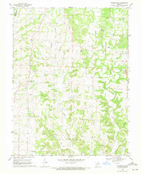
1969 Map of Sturgeon SW
USGS Topo · Published 1971About this map
Woodlandville serves as a central landmark in this 1960s landscape, where the confluence of agricultural life and early industrial activity is clearly visible. The terrain is defined by the complex drainage of Perche Creek and its many tributaries, including Callahan Creek and Silver Fork. This survey documents a rural society anchored by long-standing community institutions, with numerous country churches and cemeteries like Bethlehem Ch, Hatton Chapel, and Dripping Spring Cem scattered across the uplands.
Find a feature on this map
24 named features on this map. Tap any name to fly to it.
Don’t see what you’re looking for? This feature index may not catch every label — zoom into the map to look around manually.
Map Details
Editions of this 1969 Sturgeon SW Map
2 editions found
Other maps of this area

1886 · Jefferson City
USGS Topo · 1:125,000

1888 · Boonville
USGS Topo · 1:125,000

1890 · Moberly
USGS Topo · 1:125,000

1890 · Glasgow
USGS Topo · 1:125,000

1894 · Jefferson City
USGS Topo · 1:125,000

1917 · Sturgeon
USGS Topo · 1:62,500

1935 · Columbia
USGS Topo · 1:24,000

1940 · Columbia
USGS Topo · 1:24,000

1947 · Jefferson City
USGS Topo · 1:250,000
1948 · Columbia
USGS Topo · 1:24,000