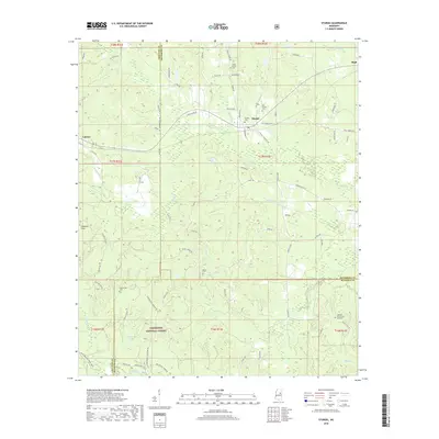
2018 Map of Sturgis
USGS Topo · Published 2018About this map
Sturgis serves as the central hub of this northern Mississippi landscape, situated at the meeting point of Oktibbeha, Choctaw, and Winston counties. The town is surrounded by a network of rural settlements and cemeteries that trace the region's family lineages, including the Old Sturgis Cem, Sturgis Cem, and Wake Forest Cem. To the west, the Noxubee Hills rise above the drainage of Sand Cr and Bogue Fallah, while the southern reaches of the map transition into the protected woodlands of the Tombigbee National Forest. This area is defined by its numerous small watercourses like Boughenia Cr and Golden Horn Cr which feed into the Noxubee River. The map preserves the specific road network of the late 2010s, connecting outlying communities like Fulcher and Bugh via routes such as Sturgis Louisville Rd and Maben Rd.
Find a feature on this map
77 named features on this map. Tap any name to fly to it.
Don’t see what you’re looking for? This feature index may not catch every label — zoom into the map to look around manually.
Map Details
Editions of this 2018 Sturgis Map
This is the sole edition of this map. No revisions or reprints were ever made.
Other maps of this area

1953 · West Point
USGS Topo · 1:250,000

1958 · West Point
USGS Topo · 1:250,000

1963 · West Point
USGS Topo · 1:250,000

1965 · Longview
USGS Topo · 1:24,000

1965 · Bradley
USGS Topo · 1:24,000

1972 · Louisville North
USGS Topo · 1:24,000

1972 · Highpoint
USGS Topo · 1:24,000

1972 · Double Springs
USGS Topo · 1:24,000

1972 · Sturgis
USGS Topo · 1:24,000
1972 · Reform
USGS Topo · 1:24,000