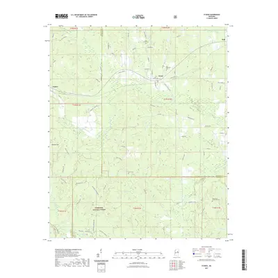
2021 Map of Sturgis
USGS Topo · Published 2021About this map
Sturgis serves as the primary hub of this 2021 landscape, situated where the terrain begins to ripple into the Noxubee Hills to the west. The area is defined by its deep connection to the Tombigbee National Forest, which blankets the southern half of the quadrangle. This forested expanse is intersected by a complex network of waterways, including the Noxubee River and Bogue Fallah, along with numerous family-named branches and creeks that drain the wooded ridges. For those tracing local heritage, the map identifies several distinct burial grounds scattered across the countryside, such as Wake Forest Cem near the northern boundary and Pleasant Hill Number One Cem to the southeast. The settlement pattern is sparse, with small communities like Fulcher and Bugh positioned along rural routes that wind through the timber and bottomlands.
Find a feature on this map
84 named features on this map. Tap any name to fly to it.
Don’t see what you’re looking for? This feature index may not catch every label — zoom into the map to look around manually.
Map Details
Editions of this 2021 Sturgis Map
This is the sole edition of this map. No revisions or reprints were ever made.
Other maps of this area

1953 · West Point
USGS Topo · 1:250,000

1958 · West Point
USGS Topo · 1:250,000

1963 · West Point
USGS Topo · 1:250,000

1965 · Longview
USGS Topo · 1:24,000

1965 · Bradley
USGS Topo · 1:24,000

1972 · Louisville North
USGS Topo · 1:24,000

1972 · Highpoint
USGS Topo · 1:24,000

1972 · Double Springs
USGS Topo · 1:24,000

1972 · Sturgis
USGS Topo · 1:24,000
1972 · Reform
USGS Topo · 1:24,000