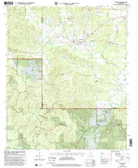
2000 Map of Sturgis
USGS Topo · Published 2002About this map
Sturgis serves as the primary hub of this landscape at the intersection of Oktibbeha, Choctaw, and Winston counties. The map captures a transition from the rolling agricultural lands of the north toward the densely wooded terrain of the Tombigbee National Forest in the south. Several small rural communities like Fulcher and Bugh are documented alongside numerous country churches, including Wake Forest Ch and Mt Zion Ch. The geography is defined by a network of drainage systems, with Sand Creek and Boughenia Creek flowing toward the Noxubee River in the southwestern corner. Local history and genealogy interests are well-served by the inclusion of family-named landmarks like the Crawford-Blackwood Cem and the Tombigbee Lookout, which provides a vantage point over the timbered ridges and the headwaters of Bearfoot Branch.
Find a feature on this map
36 named features on this map. Tap any name to fly to it.
Don’t see what you’re looking for? This feature index may not catch every label — zoom into the map to look around manually.
Map Details
Editions of this 2000 Sturgis Map
This is the sole edition of this map. No revisions or reprints were ever made.
Other maps of this area

1953 · West Point
USGS Topo · 1:250,000

1958 · West Point
USGS Topo · 1:250,000

1963 · West Point
USGS Topo · 1:250,000

1965 · Longview
USGS Topo · 1:24,000

1965 · Bradley
USGS Topo · 1:24,000

1972 · Louisville North
USGS Topo · 1:24,000

1972 · Highpoint
USGS Topo · 1:24,000

1972 · Double Springs
USGS Topo · 1:24,000

1972 · Sturgis
USGS Topo · 1:24,000
1972 · Reform
USGS Topo · 1:24,000