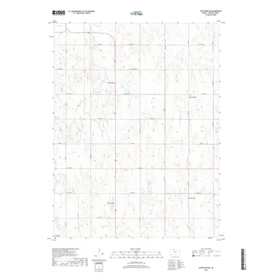
2018 Map of Stuttgart NE
USGS Topo · Published 2018About this map
Blue Mtn stands as a prominent elevation in this northern Kansas landscape, where the terrain is intricately carved by numerous creek drainages. The U.S. Geological Survey document reveals a systematic grid of section-line roads, many named for natural landmarks or early regional themes, such as W Buffalo Rd, W Cherokee Rd, and West Dakota Rd. These thoroughfares provide access across the high plains of Phillips County, connecting the various drainage basins of Plum Cr, W Crow Cr, and the forks of E Big Cr. The land remains largely rural and agricultural, divided by the township and range lines of t1s r18w and t1s r17w. This layout illustrates the enduring influence of the Public Land Survey System on the modern geography of the Central Plains.
Find a feature on this map
32 named features on this map. Tap any name to fly to it.
Don’t see what you’re looking for? This feature index may not catch every label — zoom into the map to look around manually.
Map Details
Editions of this 2018 Stuttgart NE Map
This is the sole edition of this map. No revisions or reprints were ever made.
Other maps of this area
1893 · Phillipsburg
USGS Topo · 1:125,000
1896 · Holdrege
USGS Topo · 1:125,000
1955 · Grand Island
USGS Topo · 1:250,000
1955 · Beloit
USGS Topo · 1:250,000
1957 · Grand Island
USGS Topo · 1:250,000
1958 · Grand Island
USGS Topo · 1:250,000
1959 · Beloit
USGS Topo · 1:250,000
1968 · Woodruff
USGS Topo · 1:24,000
1973 · Stuttgart NE
USGS Topo · 1:24,000
1973 · Kensington NW
USGS Topo · 1:24,000