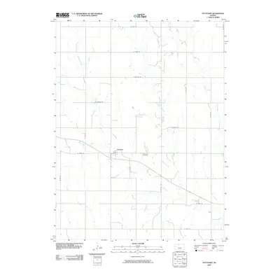
2009 Map of Stuttgart
USGS Topo · Published 2009About this map
Stuttgart serves as the central hub of this agricultural landscape in Phillips County, situated where Deer Creek cuts across the plains. This section of northern Kansas is defined by a rigorous grid of section-line roads, many bearing names reflecting Indigenous heritage like W Kiowa Rd, W Mohawk Rd, and W Navajo Rd. The drainage patterns of Boughton Creek and Bissell Creek create a subtle relief against the rectilinear property lines, revealing how the local topography has been adapted for large-scale farming.
Find a feature on this map
21 named features on this map. Tap any name to fly to it.
Don’t see what you’re looking for? This feature index may not catch every label — zoom into the map to look around manually.
Map Details
Editions of this 2009 Stuttgart Map
This is the sole edition of this map. No revisions or reprints were ever made.
Other maps of this area

1893 · Norton
USGS Topo · 1:125,000

1893 · Phillipsburg
USGS Topo · 1:125,000

1955 · Beloit
USGS Topo · 1:250,000

1959 · Beloit
USGS Topo · 1:250,000
1967 · Long Island
USGS Topo · 1:24,000

1968 · Woodruff
USGS Topo · 1:24,000

1972 · Speed
USGS Topo · 1:24,000

1972 · Phillipsburg South
USGS Topo · 1:24,000

1973 · Stuttgart NE
USGS Topo · 1:24,000
1973 · Phillipsburg North
USGS Topo · 1:24,000