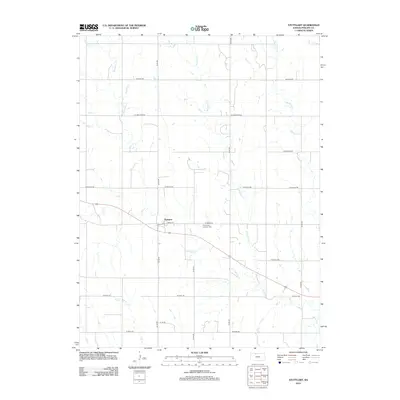
2012 Map of Stuttgart
USGS Topo · Published 2012About this map
Stuttgart serves as the central hub for this rural Phillips County landscape, situated along a network of section-line roads and the winding course of Deer Cr. The community's spiritual and ancestral heritage is anchored by the Emmanuel Lutheran Cem located just east of the main settlement area near W Osage Rd. The terrain is defined by a series of north-south drainage patterns, including Starvation Cr and Boughton Cr, which carve through the plains. The map's grid system, represented by thoroughfares like W Kiowa Rd and W Ridge Rd, illustrates the organized agricultural partitioning characteristic of the High Plains. This 2012 survey provides a clear view of how these remote watercourses, such as Bissell Cr and Hanson Cr, dictate the placement of farmsteads and rural infrastructure.
Find a feature on this map
21 named features on this map. Tap any name to fly to it.
Don’t see what you’re looking for? This feature index may not catch every label — zoom into the map to look around manually.
Map Details
Editions of this 2012 Stuttgart Map
This is the sole edition of this map. No revisions or reprints were ever made.
Other maps of this area

1893 · Norton
USGS Topo · 1:125,000

1893 · Phillipsburg
USGS Topo · 1:125,000

1955 · Beloit
USGS Topo · 1:250,000

1959 · Beloit
USGS Topo · 1:250,000
1967 · Long Island
USGS Topo · 1:24,000

1968 · Woodruff
USGS Topo · 1:24,000

1972 · Speed
USGS Topo · 1:24,000

1972 · Phillipsburg South
USGS Topo · 1:24,000

1973 · Stuttgart NE
USGS Topo · 1:24,000
1973 · Phillipsburg North
USGS Topo · 1:24,000