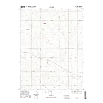
2015 Map of Stuttgart
USGS Topo · Published 2015About this map
Stuttgart serves as the central hub of this northern Kansas landscape, where the prairie is etched by an intricate network of waterways. The settlement is anchored by the Emmanuel Lutheran Cem, a significant landmark for those tracing local family lineages in Phillips County. The terrain is defined by the drainage patterns of numerous creeks, including Deer Cr, Starvation Cr, and Boughton Cr, which carve through the undulating plains. A rigid grid of section roads, with alphabetical and numerical designations such as W Jade Rd and W 700 Rd, provides the primary structure for the agricultural operations and homesteads that have defined this region for generations. This survey illustrates how the environment and human settlement patterns are deeply intertwined, with farmsteads positioned relative to the seasonal flows of Bissell Cr and Ash Cr.
Find a feature on this map
30 named features on this map. Tap any name to fly to it.
Don’t see what you’re looking for? This feature index may not catch every label — zoom into the map to look around manually.
Map Details
Editions of this 2015 Stuttgart Map
This is the sole edition of this map. No revisions or reprints were ever made.
Other maps of this area

1893 · Norton
USGS Topo · 1:125,000

1893 · Phillipsburg
USGS Topo · 1:125,000

1955 · Beloit
USGS Topo · 1:250,000

1959 · Beloit
USGS Topo · 1:250,000
1967 · Long Island
USGS Topo · 1:24,000

1968 · Woodruff
USGS Topo · 1:24,000

1972 · Speed
USGS Topo · 1:24,000

1972 · Phillipsburg South
USGS Topo · 1:24,000

1973 · Stuttgart NE
USGS Topo · 1:24,000
1973 · Phillipsburg North
USGS Topo · 1:24,000