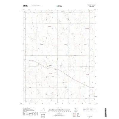
2018 Map of Stuttgart
USGS Topo · Published 2018About this map
Stuttgart serves as the central hub of this agricultural landscape in northwestern Kansas, situated along the drainage of Deer Cr. The settlement is closely tied to its local heritage, anchored by the Emmanuel Lutheran Cem located just to the east. The surrounding terrain is defined by a series of north-south drainage systems, including Starvation Cr, Boughton Cr, and Bissell Cr, which carve through the high plains. A rigid grid of section-line roads, such as W Jade Rd and W Ridge Rd, reflects the systematic land division of the Public Land Survey System that governs this region. This survey captures the enduring rural character of Phillips County, where the relationship between the small community and the expansive prairie remains central to the area's identity.
Find a feature on this map
23 named features on this map. Tap any name to fly to it.
Don’t see what you’re looking for? This feature index may not catch every label — zoom into the map to look around manually.
Map Details
Editions of this 2018 Stuttgart Map
This is the sole edition of this map. No revisions or reprints were ever made.
Other maps of this area

1893 · Norton
USGS Topo · 1:125,000

1893 · Phillipsburg
USGS Topo · 1:125,000

1955 · Beloit
USGS Topo · 1:250,000

1959 · Beloit
USGS Topo · 1:250,000
1967 · Long Island
USGS Topo · 1:24,000

1968 · Woodruff
USGS Topo · 1:24,000

1972 · Speed
USGS Topo · 1:24,000

1972 · Phillipsburg South
USGS Topo · 1:24,000

1973 · Stuttgart NE
USGS Topo · 1:24,000
1973 · Phillipsburg North
USGS Topo · 1:24,000