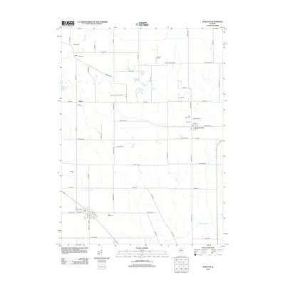
2012 Map of Sublette
USGS Topo · Published 2012About this map
The Green River meanders through the northwest corner of this agricultural landscape, a region defined by its productive family farmsteads and rural landing strips. Small settlements such as West Brooklyn and Inlet serve as local anchors, connected by a rigid grid of country roads including Richardson Rd and Shady Oaks Rd. The map reveals a high concentration of small aviation facilities like the Bernardin Landing Strip, Delhotal Airport, and Butler Hill RLA Airport, reflecting the importance of private flight for crop management and transport in this part of Illinois. Genealogists will find several burial grounds across the township, from the centrally located Union Cem to the outlying Peterson Cem and Inlet Cem. To the south, drainage from Big Bureau Cr cuts through the fields near Saint Marys Cem, illustrating the subtle hydrological patterns that shaped local land use and cemetery placement.
Find a feature on this map
53 named features on this map. Tap any name to fly to it.
Don’t see what you’re looking for? This feature index may not catch every label — zoom into the map to look around manually.
Map Details
Editions of this 2012 Sublette Map
This is the sole edition of this map. No revisions or reprints were ever made.
Other maps of this area

1918 · Dixon
USGS Topo · 1:62,500

1950 · Dixon
USGS Topo · 1:62,500

1951 · Amboy
USGS Topo · 1:62,500

1952 · Rochelle
USGS Topo · 1:62,500

1952 · Mendota
USGS Topo · 1:62,500

1958 · Aurora
USGS Topo · 1:250,000

1961 · Aurora
USGS Topo · 1:250,000
1975 · Steward
USGS Topo · 1:24,000
1975 · Ashton
USGS Topo · 1:24,000
1982 · Sublette
USGS Topo · 1:24,000