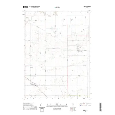
2021 Map of Sublette
USGS Topo · Published 2021About this map
Sublette sits at the intersection of US Rte 52 and H Pennsylvania Ave, anchoring a landscape of agricultural roads and private airfields in southeastern Lee County. This 2021 survey illustrates a well-ordered grid of rural sections, where legacy family names like Montavan Rd, Schmidt Rd, and Burkardt Rd define the local geography. To the northeast, West Brooklyn serves as another primary hub, while the small settlement of Shaws lies along Inlet Rd. The terrain is drained by the Green River in the northwest and Big Bureau Cr in the southeast. Genealogists will find several burial sites including Inlet Cem, Evergreen Cem, and Saint Marys Cem. A distinct concentration of small aviation facilities, including Delhotal Airport, Gehant Airport, and Butler Hill RLA Airport, points to a modern rural lifestyle intertwined with local transport infrastructure.
Find a feature on this map
54 named features on this map. Tap any name to fly to it.
Don’t see what you’re looking for? This feature index may not catch every label — zoom into the map to look around manually.
Map Details
Editions of this 2021 Sublette Map
This is the sole edition of this map. No revisions or reprints were ever made.
Other maps of this area

1918 · Dixon
USGS Topo · 1:62,500

1950 · Dixon
USGS Topo · 1:62,500

1951 · Amboy
USGS Topo · 1:62,500

1952 · Rochelle
USGS Topo · 1:62,500

1952 · Mendota
USGS Topo · 1:62,500

1958 · Aurora
USGS Topo · 1:250,000

1961 · Aurora
USGS Topo · 1:250,000
1975 · Steward
USGS Topo · 1:24,000
1975 · Ashton
USGS Topo · 1:24,000
1982 · Sublette
USGS Topo · 1:24,000