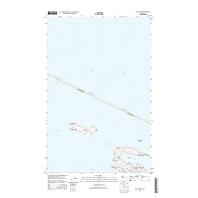
2014 Map of Sucia Island
USGS Topo · Published 2014About this map
Patos Island and the horseshoe-shaped Sucia Island anchor this maritime survey at the junction of Puget Sound, Boundary Pass, and the Strait of Georgia. Located within the San Juan Islands, these landmasses represent a critical navigational threshold near the international border. The survey highlights the complex coastline of the archipelago, including Echo Bay, Shallow Bay, and Fox Cove, alongside prominent landmarks like Patos Light at Alden Point.
Find a feature on this map
28 named features on this map. Tap any name to fly to it.
Don’t see what you’re looking for? This feature index may not catch every label — zoom into the map to look around manually.
Map Details
Editions of this 2014 Sucia Island Map
This is the sole edition of this map. No revisions or reprints were ever made.
Other maps of this area

1943 · Orcas Island
USGS Topo · 1:62,500
1952 · Point Roberts
USGS Topo · 1:24,000

1952 · Birch Point
USGS Topo · 1:24,000

1954 · Waldron Island
USGS Topo · 1:24,000

1957 · Orcas Island
USGS Topo · 1:62,500

1957 · Victoria
USGS Topo · 1:250,000

1973 · Sucia Island
USGS Topo · 1:24,000

1975 · Bellingham
USGS Topo · 1:100,000
1977 · Eastsound
USGS Topo · 1:24,000
1978 · Mt Constitution
USGS Topo · 1:24,000