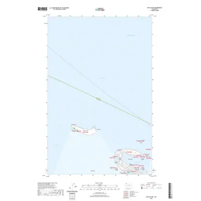
2020 Map of Sucia Island
USGS Topo · Published 2020About this map
Patos Island and the Sucia Islands archipelago anchor this 2020 topographic survey of the northernmost San Juan Islands. Situated where the Strait of Georgia meets Boundary Pass, these landmasses define a complex maritime environment. Sucia Island itself is characterized by its distinctive finger-like peninsulas, creating protected waters such as Echo Bay, Shallow Bay, and Fox Cove. To the northwest, Patos Island stands solitary with Alden Point and Toe Point marking its extremities. The map reveals the intricate coastline of smaller outcrops, including Justice Island, Harnden Island, and the Cluster Islands. The boundary between Whatcom County and San Juan County bisects the open waters of the Salish Sea, illustrating the administrative division of this northern Washington frontier.
Find a feature on this map
28 named features on this map. Tap any name to fly to it.
Don’t see what you’re looking for? This feature index may not catch every label — zoom into the map to look around manually.
Map Details
Editions of this 2020 Sucia Island Map
This is the sole edition of this map. No revisions or reprints were ever made.
Other maps of this area

1943 · Orcas Island
USGS Topo · 1:62,500
1952 · Point Roberts
USGS Topo · 1:24,000

1952 · Birch Point
USGS Topo · 1:24,000

1954 · Waldron Island
USGS Topo · 1:24,000

1957 · Orcas Island
USGS Topo · 1:62,500

1957 · Victoria
USGS Topo · 1:250,000

1973 · Sucia Island
USGS Topo · 1:24,000

1975 · Bellingham
USGS Topo · 1:100,000
1977 · Eastsound
USGS Topo · 1:24,000
1978 · Mt Constitution
USGS Topo · 1:24,000