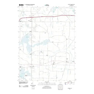
2010 Map of Suffield
USGS Topo · Published 2010About this map
The Wingfoot Lake Test Operations Balloonport south of Suffield highlights a unique aviation legacy in this corner of Portage County. The landscape is defined by its water management and agricultural history, featuring the expansive Mogadore Reservoir and smaller bodies like Muzzy Lake and Sandy Lake. A high density of cemeteries, including Restland Cemetery, Upson Meacham Cemetery, and the German Reformed Cemetery, provides a rich resource for genealogists tracing local families. The settlement pattern follows historical crossroads and rail points, from Brimfield Station in the north to the community of Saint Joseph. Drainage systems like the Feeder Canal and Hudson Ditch underscore the long-term engineering of the local terrain to support its development and industry.
Find a feature on this map
72 named features on this map. Tap any name to fly to it.
Don’t see what you’re looking for? This feature index may not catch every label — zoom into the map to look around manually.
Map Details
Editions of this 2010 Suffield Map
This is the sole edition of this map. No revisions or reprints were ever made.
Other maps of this area

1901 · Canton
USGS Topo · 1:62,500

1903 · Canton
USGS Topo · 1:62,500

1906 · Kent
USGS Topo · 1:62,500

1906 · Ravenna
USGS Topo · 1:62,500

1908 · Ravenna
USGS Topo · 1:62,500

1909 · Alliance
USGS Topo · 1:62,500

1950 · Cleveland
USGS Topo · 1:250,000

1951 · Canton
USGS Topo · 1:250,000

1953 · Canton
USGS Topo · 1:250,000
1953 · Hudson
USGS Topo · 1:24,000