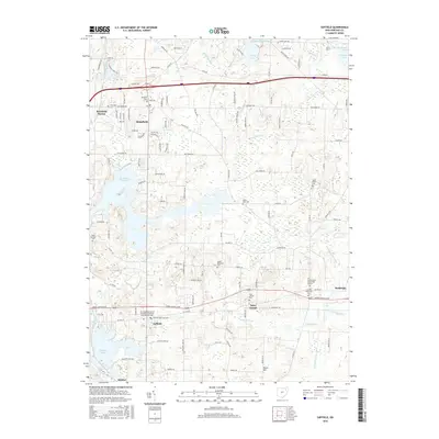
2016 Map of Suffield
USGS Topo · Published 2016About this map
Mogadore Reservoir and Wingfoot Lake dominate the hydrography of this Portage County landscape, which transitions from suburban clusters in the northwest to agricultural tracts in the southeast. The settlement of Brimfield and its nearby Brimfield Station show significant residential development near the Restland Cem and Thorndyke Cem, while the southern reaches near Mishler remain more open. Genealogists will find an exceptional density of burial sites across the township, including Saint Joseph Cem near the community of Saint Joseph, and the Randolph Hillside Cem further east. A complex network of drainage ditches, such as Randolph Ditch and Brimfield Ditch, reveals the managed nature of the local watershed. The presence of the Carnegie Institute of Integrative Medicine and Massotherapy near Suffield highlights the specialized modern land use emerging alongside traditional village centers like Randolph.
Find a feature on this map
116 named features on this map. Tap any name to fly to it.
Don’t see what you’re looking for? This feature index may not catch every label — zoom into the map to look around manually.
Map Details
Editions of this 2016 Suffield Map
This is the sole edition of this map. No revisions or reprints were ever made.
Other maps of this area

1901 · Canton
USGS Topo · 1:62,500

1903 · Canton
USGS Topo · 1:62,500

1906 · Kent
USGS Topo · 1:62,500

1906 · Ravenna
USGS Topo · 1:62,500

1908 · Ravenna
USGS Topo · 1:62,500

1909 · Alliance
USGS Topo · 1:62,500

1950 · Cleveland
USGS Topo · 1:250,000

1951 · Canton
USGS Topo · 1:250,000

1953 · Canton
USGS Topo · 1:250,000
1953 · Hudson
USGS Topo · 1:24,000