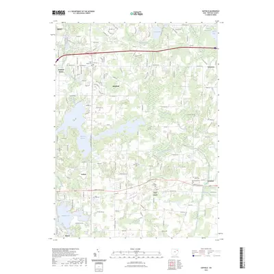
2023 Map of Suffield
USGS Topo · Published 2023About this map
The Mogadore Reservoir and Wingfoot Lake dominate this portion of the Ohio landscape, illustrating a terrain defined by significant water management and glacial hydrology. This 2023 survey of the Portage County area captures a cluster of settlements including Suffield, Brimfield, and Saint Joseph, each surrounded by a dense network of local cemeteries such as Saint Joseph Cem and the German Reformed Cem. The complex drainage patterns of Congress Lake Outlet and Breakneck Creek indicate the low-lying, well-watered nature of the region, which has long influenced the development of rural crossroads and farming communities. To the south, Bacon Hill provides a distinct topographic change in an otherwise gently undulating landscape, while the presence of the Feeder Canal reflects historic engineering efforts to direct the flow of local waterways like Potter Creek and the Brimfield Ditch.
Find a feature on this map
118 named features on this map. Tap any name to fly to it.
Don’t see what you’re looking for? This feature index may not catch every label — zoom into the map to look around manually.
Map Details
Editions of this 2023 Suffield Map
This is the sole edition of this map. No revisions or reprints were ever made.
Other maps of this area

1901 · Canton
USGS Topo · 1:62,500

1903 · Canton
USGS Topo · 1:62,500

1906 · Kent
USGS Topo · 1:62,500

1906 · Ravenna
USGS Topo · 1:62,500

1908 · Ravenna
USGS Topo · 1:62,500

1909 · Alliance
USGS Topo · 1:62,500

1950 · Cleveland
USGS Topo · 1:250,000

1951 · Canton
USGS Topo · 1:250,000

1953 · Canton
USGS Topo · 1:250,000
1953 · Hudson
USGS Topo · 1:24,000