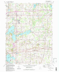
1994 Map of Suffield
USGS Topo · Published 1997About this map
Wingfoot Lake and the nearby Blimp Landing Field anchor the southwestern corner of this Portage County landscape, reflecting the region's unique connection to the airship industry. The map captures a transitional rural landscape where established townships like Brimfield, Rootstown, Suffield, and Randolph maintain their traditional centers while being bisected by the modern Conrail lines and major highway corridors. Water defines much of the terrain, from the expansive Mogadore Reservoir to the winding course of Breakneck Creek and smaller bodies like Sandy Lake.
Find a feature on this map
46 named features on this map. Tap any name to fly to it.
Don’t see what you’re looking for? This feature index may not catch every label — zoom into the map to look around manually.
Map Details
Editions of this 1994 Suffield Map
This is the sole edition of this map. No revisions or reprints were ever made.
Other maps of this area

1901 · Canton
USGS Topo · 1:62,500

1903 · Canton
USGS Topo · 1:62,500

1906 · Kent
USGS Topo · 1:62,500

1906 · Ravenna
USGS Topo · 1:62,500

1908 · Ravenna
USGS Topo · 1:62,500

1909 · Alliance
USGS Topo · 1:62,500

1950 · Cleveland
USGS Topo · 1:250,000

1951 · Canton
USGS Topo · 1:250,000

1953 · Canton
USGS Topo · 1:250,000
1953 · Hudson
USGS Topo · 1:24,000