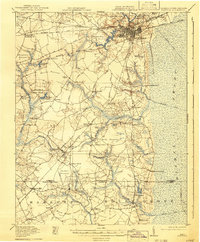
1919 Map of Suffolk
USGS Topo · Published 1941About this map
The Nansemond River headwaters and the western fringes of the Dismal Swamp dominate this landscape, which centers on the industrial and rail hub of Suffolk. At this time, the city is a critical junction for six major lines, including the Virginian Railway, Seaboard Air Line, and the Norfolk and Western, reflecting its importance as a distribution center for the region's timber and agricultural products. To the east, the Jericho Canal and Washington Ditch penetrate the swamp, while the western reaches are defined by a series of low-lying wetlands known as pocosons, including Daughtrey Pocoson and Raby Pocoson. The rural character of the outlying area is evidenced by numerous small country churches like Zion Church and specialized schoolhouses such as Bethlehem School and Baines Hill School, providing a detailed look at the dispersed settlement patterns before mid-century modernization.
Find a feature on this map
78 named features on this map. Tap any name to fly to it.
Don’t see what you’re looking for? This feature index may not catch every label — zoom into the map to look around manually.
Map Details
Editions of this 1919 Suffolk Map
3 editions found
Other maps of this area

1906 · Beckford
USGS Topo · 1:48,000

1907 · Norfolk
USGS Topo · 1:125,000

1907 · Beckford
USGS Topo · 1:62,500

1908 · Winton
USGS Topo · 1:62,500

1919 · Smithfield
USGS Topo · 1:62,500

1919 · Suffolk
USGS Topo · 1:62,500

1920 · Holland
USGS Topo · 1:62,500

1920 · Ivor
USGS Topo · 1:62,500

1921 · Newport News
USGS Topo · 1:62,500

1940 · Beckford
USGS Topo · 1:62,500