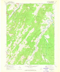
1969 Map of Sugar Grove
USGS Topo · Published 1973About this map
The South Branch Potomac River carves a path through the valley between Sandy Ridge and Neds Mountain in this 1969 topographic portrait. The landscape is defined by the sharp, parallel ridges characteristic of the Appalachian range, where small communities like Propstburg and Sugar Grove sit at the confluence of mountain runs and river bends. Significant land use is evident in the presence of the U S Naval Reservation and its associated Radio Tower facilities, contrasting with the surrounding George Washington National Forest. Local heritage is anchored by dispersed rural landmarks such as St Lukes Ch and Propst Gap Ch, alongside numerous family-named terrain features like Propst Knob and Socrates Mtn. The detailed mapping of fence lines and small cemeteries near Dahmer and Mitchell reflects the enduring agricultural boundaries of Pendleton County.
Find a feature on this map
57 named features on this map. Tap any name to fly to it.
Don’t see what you’re looking for? This feature index may not catch every label — zoom into the map to look around manually.
Map Details
Editions of this 1969 Sugar Grove Map
3 editions found
Other maps of this area

1892 · Franklin
USGS Topo · 1:125,000

1894 · Staunton
USGS Topo · 1:125,000

1896 · Franklin
USGS Topo · 1:125,000

1922 · Fort Seybert
USGS Topo · 1:48,000

1922 · Circleville
USGS Topo · 1:62,500

1924 · Circleville
USGS Topo · 1:48,000

1924 · Mc Dowell
USGS Topo · 1:62,500

1924 · Fort Seybert
USGS Topo · 1:62,500

1944 · Parnassus
USGS Topo · 1:62,500

1944 · Mc Dowell
USGS Topo · 1:62,500