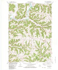
1983 Map of Sugar Grove
USGS Topo · Published 1983About this map
The Kickapoo River meanders through a landscape defined by prominent ridges and deep hollows where the borders of Vernon, Richland, and Crawford counties meet. This 1983 revision of the area shows a rural society centered around small settlements like Sugar Grove, Kickapoo Center, and Sylvan. The map captures a high density of named ridges including Sugar Grove Ridge, Buckeye Ridge, and Hustler Ridge, illustrating how the Driftless Area topography dictated the placement of homesteads and roads. Local history and genealogy researchers will find numerous family-associated landmarks and burial grounds, such as Manning Cem, Berry Cem, and St Peters Cem near the southern edge. The presence of specialized infrastructure like the Ridge Substation and private airfields such as the S & S Ranch Landing Strip reflects the modernization of this agricultural corridor in the early 1980s.
Find a feature on this map
74 named features on this map. Tap any name to fly to it.
Don’t see what you’re looking for? This feature index may not catch every label — zoom into the map to look around manually.
Map Details
Editions of this 1983 Sugar Grove Map
This is the sole edition of this map. No revisions or reprints were ever made.
Other maps of this area

1923 · Viroqua
USGS Topo · 1:62,500

1924 · Gays Mills
USGS Topo · 1:62,500

1926 · Gays Mills
USGS Topo · 1:62,500

1926 · Viroqua
USGS Topo · 1:62,500

1926 · La Farge
USGS Topo · 1:62,500

1933 · Boaz
USGS Topo · 1:62,500

1958 · La Crosse
USGS Topo · 1:250,000

1961 · La Crosse
USGS Topo · 1:250,000

1965 · La Crosse
USGS Topo · 1:250,000

1965 · La Farge
USGS Topo · 1:62,500