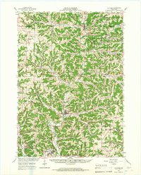
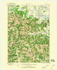
1965 Map of La Farge
USGS Topo · Published 1967About this map
The Kickapoo River winds through a landscape of sharp ridges and deep valleys, defining the geography of central Vernon County during the mid-1960s. The village of La Farge serves as a central hub, situated near the confluence of Bear Creek and the main river branch. This era shows the region's rural character preserved through numerous family and community landmarks, such as Potts Corners and several hilltop churches including Oak Ridge Ch. The topography is characterized by distinctive named elevations like Bad Axe Ridge and Wildcat Mountain, the latter protected within Wildcat Mountain State Park. Genealogists will find significant value in the distribution of local burial grounds, ranging from the Billings Creek Cem in the north to the Newburn Cem further south. The map also traces the path of State Highway 131 as it follows the river valley, connecting smaller settlements like Rockton and Ontario.
Find a feature on this map
109 named features on this map. Tap any name to fly to it.
Don’t see what you’re looking for? This feature index may not catch every label — zoom into the map to look around manually.
Map Details
Editions of this 1965 La Farge Map
This is the sole edition of this map. No revisions or reprints were ever made.
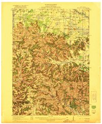
Other maps of this area

1905 · Richland Center
USGS Topo · 1:125,000

1909 · Sparta
USGS Topo · 1:62,500

1916 · Tomah
USGS Topo · 1:62,500
1919 · Kendall
USGS Topo · 1:62,500
1921 · Kendall
USGS Topo · 1:62,500

1923 · Viroqua
USGS Topo · 1:62,500

1924 · Gays Mills
USGS Topo · 1:62,500

1926 · Gays Mills
USGS Topo · 1:62,500

1926 · Viroqua
USGS Topo · 1:62,500

1926 · La Farge
USGS Topo · 1:62,500