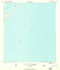
1945 Map of Sugar Hill
USGS Topo · Published 1960About this map
St George Island stretches across the northern portion of this survey, revealing the shifting coastal geography of Franklin County just after the second World War. This barrier landscape is defined by its natural defenses, including prominent Dunes and extensive areas of Sand that separate St George Sound from the open Gulf of Mexico. The landforms here are relatively sparse, highlighting the isolation of landmarks like Sugar Hill and the small Marsh I tucked along the sound-side shore. Mapped in 1944 by the U.S. Geological Survey, the document focuses on the topographical reality of this coastal stretch before modern development altered the shoreline of the Florida panhandle. It serves as a clear record of the island's primitive state, where the natural movement of wind and water dictated the shape of the dunes and marshland.
Find a feature on this map
7 named features on this map. Tap any name to fly to it.
Don’t see what you’re looking for? This feature index may not catch every label — zoom into the map to look around manually.
Map Details
Editions of this 1945 Sugar Hill Map
2 editions found
Other maps of this area

1943 · Dog Island
USGS Topo · 1:31,680

1943 · Carrabelle
USGS Topo · 1:24,000

1944 · Carrabelle
USGS Topo · 1:31,680

1944 · Green Point
USGS Topo · 1:31,680

1944 · Sugar Hill
USGS Topo · 1:31,680

1945 · Sugar Hill
USGS Topo · 1:31,680

1949 · Apalachicola
USGS Topo · 1:250,000

1950 · Goose Island
USGS Topo · 1:31,680

1957 · Apalachicola
USGS Topo · 1:250,000

1959 · Apalachicola
USGS Topo · 1:250,000