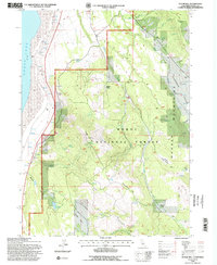
1993 Map of Sugar Hill
USGS Topo · Published 1997About this map
Goose Lake dominates the western edge of this 1993 study, where high-desert mudflats meet the rising eastern slopes of the Warner Mountains. This landscape within the Modoc National Forest is defined by its deep historical layers and rugged topography, notably the Sugar Hill summit and the Fandango Valley. Researchers will find significant cultural markers, including a Historical Marker on the lake's shore and the Site of Fandango Massacre further east, reflecting the area's difficult pioneer history.
Find a feature on this map
40 named features on this map. Tap any name to fly to it.
Don’t see what you’re looking for? This feature index may not catch every label — zoom into the map to look around manually.
Map Details
Editions of this 1993 Sugar Hill Map
2 editions found
Other maps of this area

1886 · Alturas
USGS Topo · 1:250,000

1892 · Alturas
USGS Topo · 1:250,000

1954 · Alturas
USGS Topo · 1:250,000

1958 · Alturas
USGS Topo · 1:250,000

1962 · Alturas
USGS Topo · 1:250,000

1962 · Davis Creek
USGS Topo · 1:62,500

1962 · Willow Ranch
USGS Topo · 1:62,500

1962 · Cedarville
USGS Topo · 1:62,500

1962 · Fort Bidwell
USGS Topo · 1:62,500

1965 · Alturas
USGS Topo · 1:250,000