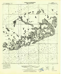
1921 Map of Sugar Loaf Key
USGS Topo · Published 1942About this map
Sugarloaf Key and its surrounding archipelago dominate this tactical reconnaissance, which details the intricate landscape of the lower Florida Keys before mid-century development. Grounded in surveys by Col. W. M. Black and 1st. Lieut. Harold Geiger, the chart documents a maritime environment defined by shallow sounds and mangrove-lined passages. Small early settlements like Big Coppitt and Stock I. are visible alongside the rail alignment that once connected these remote outposts. The map provides essential hydrographic data, including soundings across Sugar Loaf Sound (Lower) and through the Boca Chica Channel. From the northern reaches of Johnstons Key in Florida Bay to the southern waters of the Straits of Florida, the document tracks the natural geography of Cudjoe Key, Snipe Keys, and numerous smaller islets like No Name Key and Eagles Nest Key.
Find a feature on this map
51 named features on this map. Tap any name to fly to it.
Don’t see what you’re looking for? This feature index may not catch every label — zoom into the map to look around manually.
Map Details
Editions of this 1921 Sugar Loaf Key Map
2 editions found
Other maps of this area

1921 · Sugar Loaf Key
USGS Topo · 1:62,500

1921 · Key West
USGS Topo · 1:62,500

1943 · Bay Keys
USGS Topo · 1:24,000

1943 · Saddlebunch Keys
USGS Topo · 1:24,000

1943 · Boca Chica
USGS Topo · 1:24,000

1943 · Key West
USGS Topo · 1:24,000

1943 · Snipe Keys
USGS Topo · 1:24,000

1943 · Sugarloaf Key
USGS Topo · 1:24,000

1962 · Key West
USGS Topo · 1:24,000

1968 · Saddlebunch Keys
USGS Topo · 1:24,000