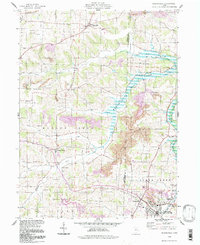
1994 Map of Sugarcreek
USGS Topo · Published 1998About this map
The Greenville Treaty Line cuts across the northern edge of this landscape, marking a deep historical division between the United States Military District to the south and Congress Lands to the north. This 1994 update of the local topography reveals a region defined by its deep valleys and the sprawling Beach City Lake, an area subject to controlled inundation along Sugar Creek. The settlement patterns of Walnut Creek and Shanesville are clearly visible, surrounded by a dense network of family-named cemeteries such as Hardscrabble Cem and Miller Cem, which reflect the area's genealogical depth. Industrial activity is prominent along the ridges, where numerous Strip Mine and Strip Mines operations are documented. The confluence of rail and water is centered on Sugarcreek, where the South Fork Sugar Creek flows past the edge of town near Barrs Mills.
Find a feature on this map
42 named features on this map. Tap any name to fly to it.
Don’t see what you’re looking for? This feature index may not catch every label — zoom into the map to look around manually.
Map Details
Editions of this 1994 Sugarcreek Map
This is the sole edition of this map. No revisions or reprints were ever made.
Other maps of this area

1911 · Newcomerstown
USGS Topo · 1:62,500

1913 · Newcomerstown
USGS Topo · 1:62,500

1913 · Coshocton
USGS Topo · 1:62,500

1914 · Navarre
USGS Topo · 1:62,500

1915 · Millersburg
USGS Topo · 1:62,500

1915 · Coshocton
USGS Topo · 1:62,500

1943 · Millersburg
USGS Topo · 1:62,500

1943 · Coshocton
USGS Topo · 1:62,500

1943 · Newcomerstown
USGS Topo · 1:62,500

1944 · Navarre
USGS Topo · 1:62,500